
Eldoret became Kenya’s newest city only after a Senate vote on 5 December 2023, but its altitude had been shaping its economy long before the title arrived. President William Ruto conferred city status on 15 August 2024, just as planners projected the population would reach 673,856 by 2026.
The map gives you a starting point, not an answer. The city sits in Kenya’s Rift Valley within Uasin Gishu County.
Yet its real logic comes from height, trade, farms, roads, power. A sharp contrast: cool highland air, hard commercial pressure.
In my honest opinion, the altitude is not a side detail here. You’ll get the plain facts first: where the city sits, why elevation changes daily life, and why this county hub matters far beyond its boundary. The surprise is how much of the story depends on what the map can’t show.
Where Eldoret sits in Kenya’s Rift Valley
The quickest way to place Eldoret is not by distance from Nairobi, but by its perch on the western shoulder of Kenya’s Rift Valley. The city sits in western Kenya, inside the Rift Valley region, where highland plateaus break the stereotype of hot, lowland western towns.
That contrast matters. It explains why the place feels more like an upland service centre than a typical valley-floor settlement.
Administratively, the city anchors Uasin Gishu County as its capital. The county covers about 3,345 km², according to the 2026 Uasin Gishu County Public-Private Sector Needs Diagnostic.
The urban core doesn’t sit on the edge of local life. It sits near the middle of it.
Look north on the map and the Cherang’any Hills give the setting its clearest reference point. The city lies south of those hills, in a zone where roads, farms, institutions, and trading routes pull traffic toward the county capital.
You don’t need a deep history lesson to see the logic. The geography does the explaining.
The useful nuance is this: the city is inland and central to the region, but its highland setting gives it a different feel from the lowland towns people expect in the west. In my view, that’s the point most quick descriptions miss. Place it only as “western” and you flatten it. Place it within the Rift Valley highlands and the map starts to make sense.
This location also helps explain why the city works as a regional meeting point. It connects agricultural areas, county administration, and transport routes without sitting on a coast or border.
That gives it a practical kind of importance. Not dramatic, but very real.
Why altitude defines the city
A traveller can land at roughly 2.1 kilometres above sea level and still be below parts of the city’s nearby high ground.
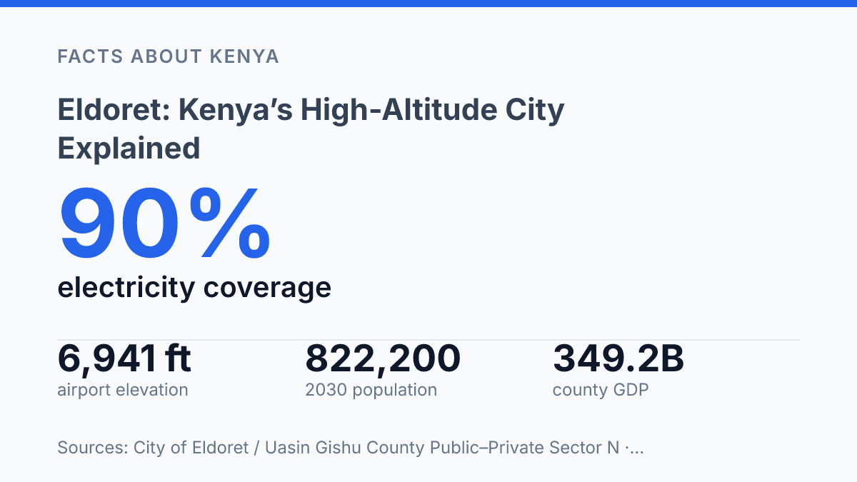
Airports-Worldwide lists Eldoret International Airport at 2,116 metres above mean sea level. The usual shorthand of about 2,100 metres is not a loose guess. That height already puts the city in a cool highland setting.
Mornings can feel sharper than visitors expect. The air has a thinner, cleaner edge that shapes how the place feels before anyone checks a forecast.
The catch is that the airport is not the whole story. Nearby areas rise to more than 2,700 metres, creating a steep local range across a short distance.
So the city should not be imagined as one flat plateau. It climbs, dips, and shifts faster than the map suggests.
That variation matters in daily life. A trip across town or toward higher ground can mean a small but real change in temperature, wind, and effort. You feel it when walking.
Drivers feel it on climbs. Farmers, athletes, and builders read the same terrain in different ways.
This is why altitude defines the city’s identity more than a simple coordinate ever could. The elevation range helps explain its cool highland character. It also explains the way people talk about “up,” “down,” and “toward the colder side” as practical directions. In my honest opinion, that vertical shift is the detail that makes the city feel distinct, not just high.
What makes Eldoret matter beyond the map
A presidential conferment on 15 August 2024 turned a long-running regional centre into a formal city, according to Kenya Law. The promotion mostly confirmed a status people already acted on.
The Senate had approved the elevation on 5 December 2023. That timing matters: it made the city’s political identity current, not historical trivia.
As the administrative centre for Uasin Gishu County, the city concentrates county decision-making in one place. Budgets, planning priorities, public works direction, and local political negotiation all pass through its institutions. That gives it a formal role that smaller towns in the county don’t have.
Being a county capital gives Eldoret formal authority, but its real weight comes from how people in the wider region use it… those two roles aren’t always the same. A county seat serves its county government. A regional city pulls in traders, students, patients, transport operators, farmers, and jobseekers from beyond administrative lines.
The numbers show why that pull is practical, not just symbolic. The City of Eldoret Urban Integrated Development Plan gives a 2019 population of 475,716, projects 673,856 by 2026, and says the city accounted for 41% of the county’s population. That means county decisions made there affect a huge share of local residents directly.
Its wider role rests on the economy around it. Uasin Gishu’s Gross County Product rose from KSh 223.8 billion in 2019 to KSh 349.2 billion in 2024, placing it 8th nationally, according to the City of Eldoret and Uasin Gishu County Public–Private Sector Needs Diagnostic. The same diagnostic estimates 44,000 active enterprises in the county, with trade and commerce forming about 52% of the enterprise base.
That business activity doesn’t float above the surrounding countryside. It is fed by farms, transport routes, markets, schools, banks, and everyday services that make the city a practical centre for western Kenya. In my humble opinion, that split is what makes the city more important than a simple label suggests.
Key facts readers usually ask first
The quick answer fits in one line. The map answer doesn’t: this is a city in western Kenya with a Rift Valley identity and a highland profile that changes fast.
Yes, it lies within the Rift Valley region. That label matters. It places the city in one of Kenya’s major geographic regions, not just in a county box on an administrative map.
For elevation, read it this way: the urban area begins around 2,100 metres above sea level and rises toward much higher nearby ground, so one neat altitude figure can flatten the real picture. That’s the catch. The city feels like one place, but its height is not one simple number.
Its city status is also recent. The Senate approved its elevation on 5 December 2023, and President William Ruto conferred city status on 15 August 2024, according to Kenya Law.
In my view, the part people miss is that the short answers are true, but incomplete. You can locate the city quickly: western Kenya, Rift Valley, high altitude.
Still, its identity works on more than one scale. It is local in its county role and national in the way its new city status now frames it.
What the city label has to prove now
The next test is not whether the city deserves its title. Kenya Law’s 2025 formalization already settled that.
What matters now is whether Uasin Gishu turns status into services that keep up with growth. More than 90% of the city has electricity coverage, but nearby rural enterprises still lose ground when roads and power sit too far away.
In my humble opinion, that gap is the story to watch. If you’re assessing the city as a visitor, investor, student, or future resident, look past the nameplate.
Watch the plain signals: water pressure, transport links, housing costs, and how fast county plans become work on the ground. A city is not made by a ceremony. It proves itself every morning when people try to move, trade, study, and get home.
Frequently Asked Questions
Q: Where is Eldoret located in Kenya?
A: Eldoret is in western Kenya, in the Rift Valley region. It sits south of the Cherang’any Hills and serves as the capital of Uasin Gishu County. That location puts it in a distinctly highland setting, not the lowland profile many people expect from Kenyan cities.
Q: Why is Eldoret called a high-altitude city?
A: Because its elevation starts at about 2,100 metres at Eldoret International Airport and rises to more than 2,700 metres in nearby areas. That kind of height changes the feel of the city fast… cooler air, thinner oxygen. A very different pace from lower-elevation places. In my view, that altitude is the city’s biggest identity marker.
Q: What county is Eldoret the capital of?
A: Eldoret is the capital of Uasin Gishu County. That makes it the county’s main administrative center, but it’s also much more than a government seat. The city carries a strong regional role in transport and commerce.
Q: How high above sea level is Eldoret?
A: The city’s elevation varies a lot. It begins at about 2,100 metres near the airport and climbs to more than 2,700 metres in surrounding areas. That spread matters because Eldoret isn’t flat… parts of it sit noticeably higher than others.
Q: What makes Eldoret different from other Kenyan cities?
A: Its altitude sets it apart first. Few urban areas in Kenya combine city life with elevations above 2,100 metres. That shapes the weather and daily feel. The surprise is that Eldoret is both a county capital and a highland city. Those two roles don’t always go together.