
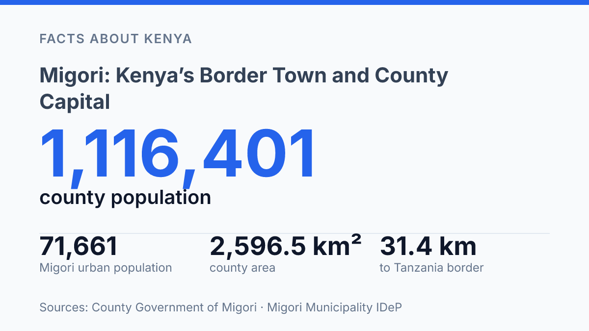
Migori is only 31.4 km from Tanzania, but its real pull runs north, west, and east across a county of more than 1.1 million people. The town isn’t a border outpost waiting for traffic to pass. It’s the administrative centre, the main urban market.
The place smaller centres measure themselves against. In the 2019 census, its urban area had 71,661 people, far ahead of Awendo, Kehancha, Rongo, Sori, Muhuru Bay, and Isibania.
That lead matters. A county can look rural on paper, with agriculture holding 60% of jobs, yet still depend on one town for services, decisions, trade, and daily movement. In my honest opinion, that’s what makes this place more revealing than a simple map pin.
The story here is location, yes, but also scale: Nairobi is 371 km away, Kisumu 182 km. The Tanzanian border close enough to shape the town’s rhythm.
Where Migori sits in western Kenya
A county capital sitting just 22 km north of the Tanzanian border carries more cross-border weight than its modest centre first suggests. The town stands 63 kilometers south of Kisii town, putting it on the southern edge of Kenya’s western highland corridor rather than deep inside the country. That position shapes how people read the place: local on the surface, regional in function.
It lies in Migori County and serves as the county capital, so its administrative pull extends well beyond the streets around the town centre. In 2024, the County Government of Migori described the wider county as part of south-western Kenya, bordering Homa Bay to the north, Kisii and Narok to the east, Tanzania to the south and Lake Victoria to the west, with an area of 2,596.5 km² including about 478 km² of water surface. That county setting gives the capital a broad hinterland to serve.
The road logic is simple but powerful. Northbound movement connects the town toward Kisii and the wider western Kenya network. Southbound travel points toward the Tanzania frontier, especially for passengers, traders and service vehicles moving through the border zone.
That’s the contrast that matters. A first-time visitor may see a practical service town: shops, offices, stages, markets and county functions. But its location turns it into a stopping point on routes linking western Kenya to Tanzania. In my view, the border is the detail that explains the town better than its size does.
What makes the town socially and economically distinct
The town’s strongest commercial asset isn’t a single industry. It’s the habit of switching languages, customers, and supply routes in the same trading day.
Known locally as Suna-Migori, the municipality is a multi-ethnic town in a practical, everyday sense. People don’t just live beside each other.
They trade, rent rooms, run transport, attend services, and build networks across community lines. That mix gives the town a wider social reach than a more culturally uniform centre would have.
Commerce reflects that mix most clearly. Shops, open-air markets, transport yards, food traders, and produce buyers serve residents from the core municipality and from the wider Migori Metropolitan area.
Trade doesn’t stop at the old town centre. It pulls in activity from adjacent smaller centres such as Suna Central, Kakrao, Ragana-Oruba, Waswetta II, and God-Jope, named in the municipality’s 2023 Integrated Development Plan.
Agriculture still feeds much of this urban exchange. According to the County Government’s 2024 planning documents, farming accounts for 60% of total county employment.
That matters inside town. It turns markets, storage yards, repair shops, mobile money agents, and small eateries into part of a wider rural-urban system.
But the same diversity that makes the town commercially flexible also makes it harder to reduce to one dominant identity. The place is shaped by movement and mixing. People arrive to sell, study, work, seek services, or connect onward.
Some stay. Some keep moving.
That’s the point many neat town profiles miss. In my honest opinion, the municipality’s identity is strongest when it’s understood as a meeting point, not as a place owned by one story. Its social character is practical before it is symbolic: who can trade with whom, who can find a room, who can get goods moved, and who can build a life across several networks at once.
Migori Metropolitan area and nearby settlements
A 49 km² municipal core being planned as a 202.7 km² urban area changes the map more than it changes the name.
The Migori Metropolitan area consists of Migori municipality and adjacent smaller towns. That simple description hides a real shift in how the town functions.
The smaller settlements don’t sit outside the urban story. They absorb housing, roadside trade, schools, workshops, and daily movement that the older boundary can’t contain.
In practice, the municipality acts as the anchor, not the whole city. People may work, study, shop, or seek services in the core during the day, then return to homes in adjoining settlements by evening. That pattern makes the edge feel less like a line and more like a gradient.
Here is the tension: the official town is neat on paper. The lived urban area is wider, messier, and harder to govern. According to the 2023 municipal Integrated Development Plan, the older municipality covered about 49 km².
The expanded planning area is more than four times that size. That comparison shows why the urban footprint can’t be understood through the historic boundary alone.
The same plan placed the expanded area’s population at 127,590 in 2012 and projected it to reach 252,391 by 2030, using a 5.1% urban growth rate. That’s not just a bigger headcount. It means roads, land-use control, drainage, waste handling, and public facilities have to be planned across a connected urban zone.
Nearby settlements gain from this pull. They also carry pressure that residents feel first: land prices, traffic, and demand for basic services. In my humble opinion, the municipal line is the least useful way to understand this urban area. The better measure is dependence: if a settlement relies on the core for services, markets, and transport links, it already belongs to the wider urban system.
Why Migori matters in Migori County
The town is the capital of Migori County, Kenya, a county that had 1,116,401 people in the 2019 census, according to the county’s 2024 planning documents. That makes the town more than a commercial stop. It is where county decisions become queues, files, permits, clinic referrals, and public notices.
Capital status pulls routine government work into one urban centre. County capitals normally concentrate executive administration, revenue counters, planning desks, and service coordination offices. For residents, that matters in practical ways: a business permit, a building approval, a public health query, or a county job notice is easier to follow when the main offices sit in one recognized place.
The scale behind that role is large. The same county documents project 1,292,006 residents in 2025 across 12 sub-counties and 40 electoral wards.
A capital has to translate that spread-out population into reachable services. It becomes the front door for people who may live far from the main office but still depend on county systems.
Authority has a cost. More offices bring more movement, and more movement strains roads, parking, drainage, waste handling, and waiting areas.
Municipal planning data from 2023 recorded 99% mobile network coverage and about 90% household electricity connection, but also no sewerage treatment plant. That contrast says a lot: public access has improved in some ways, yet basic urban systems still carry heavy pressure.
County status also changes expectations. People don’t treat the town like an ordinary market centre. They expect answers, records, signatures, and follow-up. In my view, that is the real measure of its importance.
The capital shortens the distance to authority for many residents. It can also lengthen the line once they arrive.
What the next map will have to show
The next test won’t be whether the town grows. It will.
The harder question is whether growth produces a better urban centre or just a larger one. By 2030, the expanded municipality is projected to reach 252,391 people, with neighbourhood anchors such as Suna Central carrying more of the load.
That puts pressure on choices that sound dull until they fail: drainage, waste, local roads, sewerage, land control. Mobile coverage and electricity already show what can move fast.
The missing sewerage treatment plant shows what can’t be ignored forever. In my humble opinion, the real story is not border-town charm. It’s whether planning catches up before convenience turns into strain.
Frequently Asked Questions
Q: Where is Migori located in Kenya?
A: Migori sits in southern Kenya, 63 kilometers south of Kisii town and 22 km north of the Tanzanian border. That location makes it a true border town, not just a stop on the way south. It matters because cross-border movement shapes the town’s economy and daily life.
Q: Is Migori the capital of Migori County?
A: Yes. Migori serves as the capital of Migori County. It carries the county’s main administrative role. That gives it more weight than a typical town of its size.
Q: What is another name for Migori town?
A: Migori is also known as Suna-Migori. That name reflects the town’s local identity and its close link to the surrounding area. In my view, that dual name is a clue that the town’s character is broader than a simple map label.
Q: How far is Migori from the Tanzanian border?
A: Migori is 22 km north of the Tanzanian border. That short distance is a big deal for travel and trade. It also means the town feels more connected to cross-border routes than inland centers do. If you’re planning a trip, that proximity matters.
Q: What is the Migori Metropolitan area?
A: The Migori Metropolitan area includes Migori municipality and the nearby smaller towns around it. So when people talk about Migori, they’re often talking about more than the core town alone. That wider area gives the town extra reach and daily traffic.