
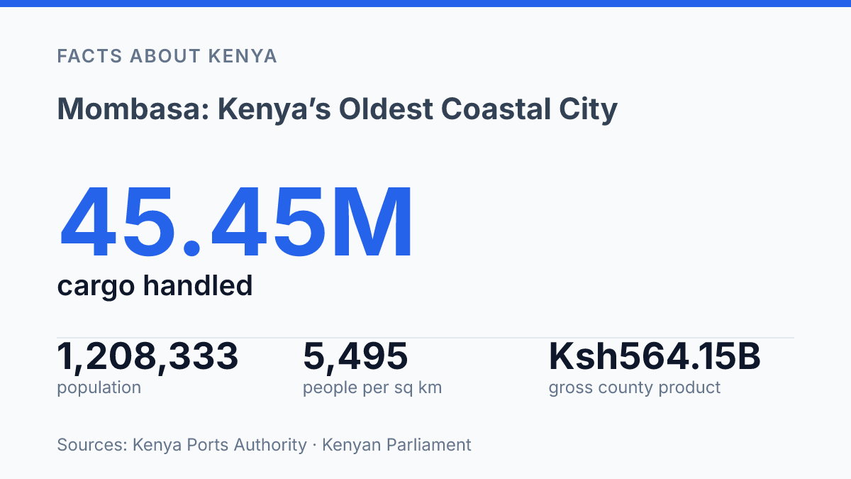
Mombasa has almost 2,000 years of settlement under its streets, yet its port handled 45.45 million metric tons of cargo in 2025. That clash is the point.
The city isn’t a relic with a beach attached. It’s a working coastal engine built on layers of trade, conquest, railway politics, and crowded urban growth.
Fort Jesus gives the story its sharpest stone outline. The Portuguese built it at the end of the 16th century, and UNESCO inscribed it in 2011. But the deeper story starts before Europe arrived.
It doesn’t stop when Nairobi takes the administrative crown in 1907, 327 rail miles inland. This guide follows that longer arc: a medieval port that learned to survive empire, a colonial gateway that lost political power. A dense modern city that still refuses to feel like Nairobi. In my honest opinion, that’s exactly why it matters.
How the city grew from a medieval port
Mombasa was already old by the time many inland towns entered the historical record. Its commonly cited origin around c. 900 A.D. makes it Kenya’s oldest city. That age still changes how people read its streets, ruins, names, and shoreline.
This wasn’t a settlement that grew by accident. It sat on the Indian Ocean coast in southeastern Kenya, exactly where monsoon winds, maritime routes, and regional exchange could turn a small island town into a serious port.
Research in the Journal of Archaeological Science places settlement on the island at almost 2,000 years, notes its rise by the 16th century as a centre of sustained port dominance, and records 2001 surveys that found submerged archaeological potential in the harbour. That detail matters.
The city’s history doesn’t sit only in walls and old lanes. Some of it lies under the water, where trade, ship traffic, and coastal life left traces that still haven’t been fully read.
Trade gave the early city wealth. It also made identity complicated. African, Arab, Persian, Indian, and later European influences moved through the port over centuries. Some arrived through commerce.
Others came through conquest or control. That mix produced a distinctive coastal culture. It also means no single origin story can explain the place cleanly.
This is where its age becomes both pride and pressure. Being the country’s oldest city gives it a status Nairobi can’t copy. That same depth makes the past layered rather than simple. In my view, the most honest way to understand the city is not as a relic, but as a port that kept absorbing the world without ever becoming just one thing.
Why Mombasa mattered to British East Africa
The capital moved in 1907. The harder truth was that colonial authority had never meant the same thing as coastal power.
Mombasa was the first capital of British East Africa. That choice made practical sense. It had a harbour, established commercial links.
A coastal position that colonial officials could read as access and control. The city gave the protectorate an outward-facing base before the inland administration had fully taken shape.
Nairobi changed that calculation fast. According to the 1911 Encyclopaedia Britannica entry, Nairobi lay 327 miles by rail northwest of the coast.
The protectorate’s administrative headquarters were transferred there in 1907. Its recorded population that year was only 4,737, a small number for a place about to become the centre of colonial government.
That is the revealing part. Political power did not move inland because the coast had stopped mattering. It moved because the railway and the interior had become the new priorities of colonial rule.
Losing capital status did not erase Mombasa’s importance… it exposed the gap between political headquarters and economic weight. The city’s older trading role was rooted in maritime exchange, merchant networks, and port access. Colonial administration worked differently.
It needed files, officers, land routes. A central position from which to manage the interior.
In my honest opinion, that split is the key to understanding the city’s colonial-era significance. Nairobi gained the offices. The coast kept the gateway.
One city became the command centre. The other remained the door through which much of the colony still connected to the wider world.
What the modern city looks like today
The CBD wears the ocean on its walls: many public-facing buildings use blue and white as a civic palette, turning the Indian Ocean into part of the city’s everyday visual code. That choice matters. It gives the centre a clear coastal identity without turning the whole place into a postcard.
Today, the city serves as the capital of Mombasa County, so its core is both symbolic and practical. County offices, commercial blocks, transport links, and service hubs sit close together. You feel that compression at street level.
The city doesn’t spread its authority across a distant administrative quarter. It keeps much of it in the middle of daily movement.
The surprise is scale. For all its coastal cues, this is not a small seaside city living off nostalgia. The 2019 census recorded a population of about 1,208,333, according to Kenyan Parliament/PBO County Fact Sheets.
That makes it Kenya’s second-largest city after Nairobi. That fact changes how you read the streets.
Density sharpens the point. The same county fact sheets record 0 rural residents, 378,422 households, and 5,495 people per square kilometre. Those numbers describe a fully urban county, not a town with a loose rural edge.
The tradeoff is clear: the compact coastal character gives the city its strong identity. The pressure of people, traffic, housing, and services makes it feel far larger than its island-and-mainland geography suggests.
In my humble opinion, the blue-and-white CBD works because it doesn’t pretend the city is only a beach destination. It signals the coast. The crowding, county functions, and commercial weight tell a harder truth.
This is a governing centre, a dense urban economy. A coastal city all at once.
Why the city still stands apart from Nairobi
Kenya’s second-largest city after Nairobi has a clearer physical signature than the capital: saltwater, ferries, creek edges. The open Indian Ocean. That ranking matters.
It doesn’t explain the difference. Size is the least interesting comparison here.
Nairobi holds the national spotlight. It is inland, political, corporate, and fast-moving in a way that suits a capital city. The coastal city feels different because geography keeps announcing itself.
You don’t have to search for its identity. The shoreline does half the work.
That physical edge shapes daily life in practical ways. Movement depends on bridges, ferries, port roads, and weather in a way an inland city doesn’t experience. Commerce also faces the sea.
In 2025, the port handled 45.45 million metric tons of cargo, according to Kenya Ports Authority. The waterfront isn’t just scenery. It is national infrastructure with tides, cranes, trucks, and ships attached to it.
Public image follows the same line. The city is marketed through the coast: beaches, seafood, Swahili-inflected street life, dhow imagery, sea-facing hotels. The slower social rhythm that visitors associate with the shore.
But that image can flatten the place if you’re not careful. The coast is leisure for some people and hard work for others.
The contrast with Nairobi is sharp for that reason. Nairobi can absorb people into a broad national story, then keep reinventing itself through politics, business, media, and construction. The coastal city carries a more fixed sense of place. In my view, that geographic clarity matters more than the second-place ranking.
So the two cities don’t compete only by population or status. One projects national command from inland.
The other projects Kenya outward through the sea. That is why the coastal city still stands apart: not because it is smaller, but because it is harder to detach from its edge of the map.
What the coast still understands better than the capital
Treat Mombasa as a city with choices ahead, not a preserved stop on a coast itinerary. By 2027, county plans project 1,422,443 residents, with a larger working-age share than before.
That can mean jobs, port growth, and better streets. It can also mean sharper pressure on land, housing, water, and heritage sites that can’t be rebuilt once they’re cheapened.
The practical next step is simple: read the city through movement. Watch the cargo, the ferries, the old walls, the cruise terminal crowds. The train line to Nairobi. In my humble opinion, the old mistake is treating the coast as secondary because power moved inland.
The coast didn’t stop leading. It just led in a different language.
Frequently Asked Questions
Q: Why is Mombasa historically important?
A: Mombasa matters because it’s Kenya’s oldest city, with roots going back to around 900 A.D.. It also served as the first capital of British East Africa before Nairobi took over in 1907. In my view, that mix of deep history and colonial power shift gives the city real weight.
Q: Is Mombasa the capital of Kenya?
A: No, Nairobi is Kenya’s national capital. Mombasa is the capital of Mombasa County. It still holds major local authority. That’s the part people miss… it’s not the national seat, but it’s still a serious administrative center.
Q: How big is Mombasa’s population?
A: Mombasa had about 1,208,333 people in the 2019 census. That makes it Kenya’s second-largest city after Nairobi. The city is large enough to feel busy, but its coastal identity still shapes how it looks and moves.
Q: What does the blue and white CBD in Mombasa mean?
A: The blue and white buildings in Mombasa’s Central Business District represent the Indian Ocean. It’s a simple visual choice. It gives the city a clear coastal identity. You see it right away, and that’s exactly the point.
Q: Where is Mombasa located in Kenya?
A: Mombasa sits in southeastern Kenya along the Indian Ocean. That location made it a natural port city. It also shaped its history as a place of trade, contact, and change. The coast isn’t just scenery here. It’s the city’s reason for being.